


Unparalleled performance with a wide range of frequencies for applications ranging from deep mineral exploration and glaciology to high resolution geotechnical investigations and concrete imaging.
The Boone Pickens School of Geology (BPSoG) at Oklahoma State University (OSU) conducting a field acquisition project for their new Environmental Geophysics course collect low center frequency pulseEKKO GPR data over a suspected fault.
The target of investigation was a 4 km long escarpment with about 15-20 meters of topographic variation along the Cimarron River drainage in southwestern Payne County, Oklahoma, provisionally called the Coyle Escarpment, which may represent an unrecognized fault. This location provided an intriguing scientific objective close to the OSU campus, accessible on public property along county roads.
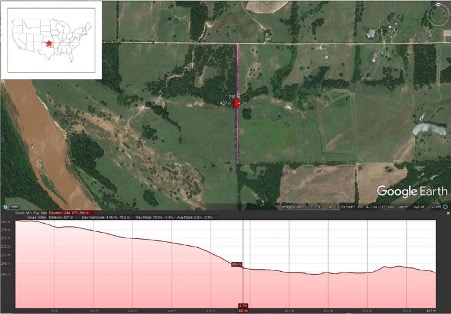

N-S topographic profile across ~W-E-striking Coyle escarpment (marked by vegetation) showing ~15-20 m of relief along a linear trend within the Cimarron River drainage in southwestern Payne County, OK (see inset). Red arrow in figure marks base of escarpment; pink line (~800 m) shows location of geophysical profiles
Common mid-point (CMP) profiles were collected along the transect (Figure 4) with the 50 MHz antennae, used to determine the electromagnetic velocity to be ~0.116 m/ns.
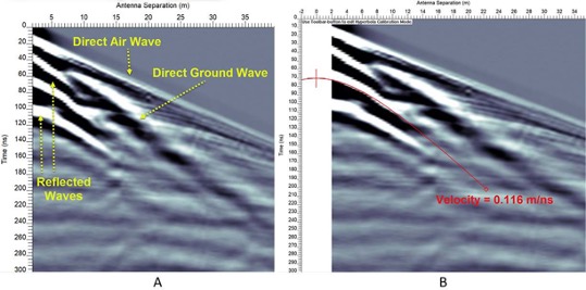

Common Mid-Point (CMP) gather of 50 MHz center frequency antennae collected with expanding (40 m) spread on profile north of escarpment. (A) Identification of arrivals. (B) Normal moveout (NMO) on reflections between 30-130 ns implies a velocity of 0.116 m/ns for the shallow subsurface